

The next Mississippi River mega flood in Louisiana could see its water overwhelm the Old River Control Structure above Baton Rouge and cause the river to switch its flow to the Atchafalaya River basin, according to a research scientist with the Louisiana State University School of Renewable Natural Resources.
Such a shift would leave 2 million people living in New Orleans and other communities that rely on the Mississippi or Bayou Lafourche for drinking water with water too salty to drink, said hydrologist Yi-Jun Xu during an interview Tuesday (Dec. 12) at the 2017 American Geophysical Union fall meeting in New Orleans. Salt water from the Gulf of Mexico would move far enough upriver to cause the freshwater aquifer used by Baton Rouge for its drinking water to become too salty, too, he said.
More than 100 petrochemical plants between Baton Rouge and the Gulf of Mexico that rely on Mississippi River water would also be affected.
"It will cause widespread flooding in the Atchafalaya (river basin) and Morgan City will probably be gone, covered with water," Xu said. Sediment from the Mississippi also would fill the present Atchafalaya Bay within 30 years, he said.
But the cutoff of the majority of the river's flow downstream along its present birds foot delta would also starve that area of sediment and make proposed major Mississippi River sediment diversion structures ineffective, he said.
A spokesman for the New Orleans District office of the Army Corps of Engineers said the agency is aware of the issue involving the filling of the Mississippi river bed.
"We have been monitoring changes, including sediment accumulation, in the lower Mississippi River for many years, in order to keep abreast of any changes that could impact our ability to manage floods safely in South Louisiana," said spokesman Ricky Boyett.
"We are now in the process of completing a Mississippi River assessment to gain greater insight into changes in the watershed and their effects so that river floods can continue to be managed well into the future," he said. "Similar to our refinement of the Morganza Control Structure operating procedures following the 2011 Mississippi River high water event, the Corps would seek input from all stakeholders and the public prior to undertaking any measures to alter the existing project."
The Morganza spillway, between the Old River structure and Baton Rouge, is used during high river events to move excess water in the river into the Atchafalaya.
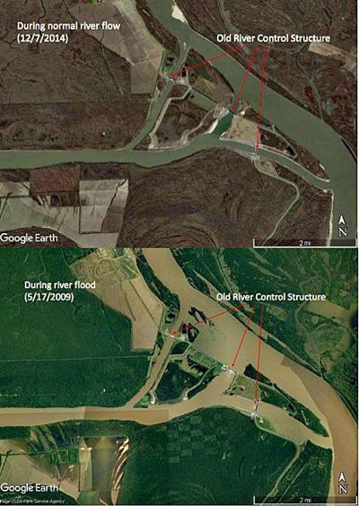
What's leading to the potential river bed switch is the filling of the Mississippi's river bed with sediment along an area just below the Old River Control Structure. That section of the river bed has risen more than 30 feet in the past 20 years, leaving less room for the water carried by the flow to the Gulf. During a major flood, it will act like a stopper, causing water to back up and rise higher than the present Old River Control structures.
A segment of the river channel at Angola Landing below the river control structure, adjacent to the state prison, also has narrowed by as much as 2,500 feet, he said, which also limits the flow of water downstream.
"There are two conditions that cause a river to change its channel, very simple," Xu said. "Number one is aggradation of the channel bed, and number two, a mega flood. The channel aggradation is already there. We are only waiting for the flood. If we had a mega flood next spring, in 2018, it could happen."
"In 2009 during a spring flood, not a mega flood like occurred in 2011, the control structures were nearly overpowered," Xu said.
"Because of this, the river's flow capacity has been reduced. For the same amount of water flow, the river stage (the top of the river water) is much higher today than 30 years ago," he said.
The complex of gates that transfer 30 percent of the Mississippi's flow to the Atchafalaya year-round was completed in 1963, with additional structures added after a 1973 flood threatened to cause the original structures to fail. The 30 percent split of the river's flow was set by Congress.
Those gates, the levees all along the river from the state's border with Arkansas to Plaquemines Parish and the jetties that anchor the present river channel into the Gulf have kept the river from doing what it does naturally.
"The Mississippi is a large alluvial river, which means the sediment it transports decides where it will go," Xu said. "The river has changed its course many times over the last several thousand years. On average, every thousand years, the river switched its course."
That always happened at a point near or just above the Old River Control Structure.
The Atchafalaya River basin was formed as part of earlier delta formations of the Mississippi to its east and west, and by the flow of the Red River from Texas into central Louisiana. In 1831, a pathway was dredged between a distributary of the Mississippi and the Red, leading to the formation of the present Atchafalaya river channel. The river still carries water from the Red River.
Xu also is concerned about the development of a series of sand bars that have elevated segments of the Mississippi river bottom upriver between the river control structure and Vicksburg. That area contains "530 million tons of sediment, pure sand," Xu said.
He said future floods could dislodge that sand and wash it downstream, where it could rapidly raise the river bottom just south of the control structure, making the plugging effect even more dangerous, he said.
"The risk is real," he said, and comes with life-changing consequences. "This is gigantic and conventional thinking might not work here."
Xu suggested two potential fixes. The first is to mine the sediment where the river bottom is too high and narrow below the river control structure and from the sand bars between the structure and Vicksburg and pumping it hundreds of miles through a pipeline to the south, where it can be used for the state's coastal restoration program.
Another alternative is to set off dynamite charges along the elevated river bottom during high river periods, which would cause the sand and sediment to be suspended in the river and carried downstream.
Both have their own problems and risks, including their cost and the potential effects to downstream areas from the additional sediment resulting from the explosions, which could cause its own flooding concerns or problems for shipping, he said.
"But we don't have many other choices here," he said.
This story was updated at 8 p.m. Tuesday (Dec. 12) to include comments by the Army Corps of Engineers about actions they are taking to review the effects of sediment filling in the Mississippi's river bottom.
Below is the poster presentation made by LSU hydrologist Yi-Jun Xu: