Question: What is a hydrocarbon trap? Answer: A trap consists of an impervious stratum that overlies the reservoir rock thereby prohibiting hydrocarbons from escaping upward and laterally. This impervious stratum is called a roof rock; it intervenes to collect and hold hydrocarbons underground. The roof forms a seal, or a barrier, which creates the needed conditions for a pool. Trap material must have a lower permeability than the existing rock material though which the hydrocarbons are flowing. The rock forming the seal is also referred to as a capping bed.
We need to reiterate two important concepts, porosity and permeability
and how they relate to source rocks and reservoir rocks. Porosity
controls the volume of hydrocarbons present in a given trap while
permeability controls the volume of hydrocarbons that can be extracted
from the trap.
Most of the hydrocarbons that forms in sediments does not find a
suitable trap and eventually flows to the surface along with the
formation water. It is estimated that less than 0.1% of all organic
matter originally buried becomes trapped in an oil pool. The greatest ratio of hydrocarbon pools to volume of sediment is found in rock no older than
2.5 million years and almost 60% of all oil discovered thus far is found
in strata of Cenozoic age.
Question: Why do you think 60% of the oil found is in strata of Cenozoic age? Answer: Age implies the length of time the hydrocarbons have been subjected to temperature variations. The longer hydrocarbons are pooled in the subsurface, the more susceptible they are to high temperatures & tectonic processes. All of these tend to vaporize the hydrocarbons or breech cap rock allowing product to vent to the surface and be lost.
Review:
A reservoir rock is created if a trapping mechanism is present and creates a place to contain the accumulated hydrocarbons. The trap consists of a roof rock, an impervious stratum, that overlies the reservoir rock and prohibits hydrocarbons from escaping upward or laterally. Roof rock forms a seal, or a barrier, which creates needed conditions for a pool. The rock material must have a lower permeability than existing rock material though which the hydrocarbons are moving. The rock forming the seal is also referred to as a capping bed.
Question: Do all reservoir rocks contain hydrocarbons? Answer: No - conditions favorable for containment, but nothing migrated into it
Question: Once hydrocarbons are trapped in reservoir rock, will they remain there forever? Answer: No - if the capping bed is breached (tectonic forces, man made), hydrocarbons are free to move out through the breach and collect
somewhere else or will eventually reach the surface where they will vent
and be lost.
Question: Could production be accomplished from source rock through which hydrocarbons are moving? Answer: Probably not with current technology.
Hydrocarbons are in the form of small oil droplets; they have not accumulated into "pools" and cannot be economically extracted from the free water.
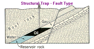
There are three basic types of hydrocarbon traps:
Structural traps are created when the seal or barrier is concave upward (looking from below). The geometry is formed by tectonic processes AFTER deposition of the reservoir beds involved.
There are two types of structural traps:
Folds result in the physical bending (deformation) of the rock units without breaking. The simplest form is an anticline -- creating an Anticline trap. The rock units undergo bending very slowly over long periods of geologic time. These types of traps are often found adjacent to mountain ranges.
The second type of Structural trap is a Fault trap. These are the result of fractures (breaks) within the rock units where one side has moved relative to the other side. Faulting may be the sole cause of the formation of a trap or more commonly, faults form traps in combination with other structural features such as folding
Click to view an example of folding due to faulting and a dome formation.
which is common along the Gulf Coast region
of Louisiana. Often an oil field is the result of multiple faulting
forming many structural traps containing hydrocarbons as in the case of
the Jennings Field near Jennings, Louisiana. Click for more details about the types of faults.
Stratigraphic traps are created when the seal or barrier is formed by changes in lithology or rock type (which also controls porosity and permeability), DURING the deposition of the reservoir beds involved. Lithological variations may be depositional,
as in the case of reefs , channels, and sand bars. A Louisiana example of this type of is (Echols)
Lithological variations may also be post-depositional in nature;
truncations occur where erosion has removed a significant portion of an existing tilted structure followed by deposition of another lithologic rock unit, the latter forming the roof rock and thus becoming the capping bed. An example is the Monroe gas field in Morehouse Parish.
The third type of hydrocarbon trap is called a Combination Trap. The geometry of this type of trap is the result of a combination of tectonic processes and changes in lithology. A common trap that would be an example of a Combination Trap is a salt dome. A salt dome is a mass of NaCl (Sodium Chloride) generally of a cylindrical shape and with a diameter of about 2 km near the surface, though the size and shape of the dome can vary. This mass of salt has between pushed upward from below through the surrounding rock and sediments into its present position. The source of the salt lies as a deeply buried layer that was formed in the geologic past. Salt is an
evaporite. Salt beds were formed by the natural evaporation of sea water from an enclosed basin; in Louisiana, this occurred in Permian or Jurassic time. Subsequently, the precipitated salt layer is buried by successive layers of sediments over geologic time until segments of it begin to flow upward toward the surface of the earth.
Review Question:
Question: There are three basic types of hydrocarbon traps: Structural, Stratigraphic, and Combination traps. What is the difference between each of the three trap types in terms of how they were formed? Answer: A Structural trap is formed by tectonic processes AFTER
deposition of the reservoir beds involved while a Stratigraphic trap is
created during deposition of the reservoir beds. A Combination trap is
formed by a combination of processes present in the sediments DURING the
time of deposition of the reservoir beds AND by tectonic activity that
occurred in the reservoir beds after their deposition.
The origin of salt domes is best explained by the plastic-flow theory.
Salt has a density of 2.2 under standard conditions. But at a depth of
about 12,000 feet, the mass of the overlying sediments exerts a
compressive, downward force, density decreases and salt begins to flow like a plastic substance. A small fracture in the overlying, higher density sediments or a slightly elevated mass of salt above its surroundings would trigger the upward movement. Once this upward salt movement begins, salt from
elsewhere in the salt bed moves into the region surrounding the salt
plug to replace the salt that is flowing upward to form the salt plug.
The upward movement of the salt plug, or dome, continues as long as
there is sufficient source of salt "feeding" the dome OR until the
upward movement is halted by a more rigid formation. Once equilibrium is reached, upward movement of the salt dome ceases, but may begin again if sufficient sediments are added to the weight of the overburden which again increases the load pressure on the parent salt mass. In Louisiana, the age of the salt domes is dependent upon which side of the Cretaceous reef structure you are on. The domes are oldest on the north side and youngest on the south side. This also corresponds to the age of the hydrocarbon deposits discussed earlier.
Question: Why, in Louisiana, would the age of the salt domes approximate the age of the hydrocarbon deposits? Answer: Louisiana was formed over geologic time with the older sediments located in the north and progressively younger sediments building southward. It would follow that the age of the salt domes would also reflect this trend.
Salt domes come in all sizes and shapes, but all have certain
characteristics. For example, they have a cap rock. The cap rock is composed of limestone located at the top of the dome followed by, in descending order, gypsum, anhydrite, and finally rock salt. The average cap rock is between 300 to 400 feet thick, but cap rock up to 1,000 feet thick
are known to exist.
NOTE: Cap rock was first thought to form during the initial precipitation of
the evaporite, the rock salt, and that it was a top layer that was the
last unit to form in the enclosed basin [rock salt overlain by
limestone]. This theory has been discarded in favor
of one that considers cap rock as a secondary product that is created as
the salt dome ascends through the overlying materials. The top of the
dome dissolves as it rises through the sediments and the residual
constituents of the salt become concentrated at the top of the rising
plug becoming three layers: limestone, gypsum, and anhydrite.
The cap rock of some salt domes, and sometimes the rock salt itself, is
found to overhang, or drape down, the side of the main salt mass. It is commonly found to overhang on one or two sides. The reason for the overhang probably is dependent upon the nature of circulating waters in the sediments through which the dome is ascending. Salt is soluble and dissolves, but the cap rock is not very soluble and is left more intact. Thus the appearance of the cap rock "overhanging" the main salt body is the result of disolutioning of the salt body within the subsurface, but not dissolving the cap rock.
Cap rock has all the characteristics of a petroleum reservoir and often
contains hydrocarbons. But cap rock also contains free sulfur. Free sulfur is present in cap rock of almost all salt domes, but it occurs in
commercial quantities only in salt domes that have a thick limestone
cap. The free sulfur forms after the limestone is created and the
sulfur is probably derived from the destruction of the anhydrite.
Louisiana has many salt domes, over 100 that have been identified and mapped. In Louisiana and the Gulf Coast region, the salt has moved up through thousands of feet of sediments and the upward motion of the salt is still going on especially in South Louisiana.
Question: Are salt domes source materials; i.e., do they have anything to do
with the origin of hydrocarbons? Answer: No! Salt domes account only for creating reservoir traps.
Before leaving this discussion, it is important to understand that in
the early days of petroleum exploration in the U.S.A., there was no
specific legislation governing it. Legal battles often ensued regarding
ownership issues, so the courts applied wildlife game rules to
hydrocarbons. The justification for this was that oil and gas were
considered fugacious, likely to flee, and could move from property to
property. Law was eventually established that the petroleum was owned
by the person under whose land they were trapped. This perception as
set forth over a century ago, is adhered to today.
REFERENCES
DOTT, R. H., and M. J. REYNOLDS, 1969, Source book for Petroleum
Geology: Am. Assoc. Petrol. Geol., Mem. No. 5, 471 pp.
JUDSON, SIDNEY A. and R. A. STAMEY, 1933, Overhanging Salt On Domes of
Texas and Louisiana: Bull. Am. Assoc. Petrol. Geol., Vol. 17, pp.
1492-1520.
Other Materials Utilized in Preparation of this Section
BATES, R. L. AND J. A. JACKSON, 1980, Glossary of Geology: American
Geological Institute, Falls Church, VA., 2nd Ed., 749 pp.
BERGER, B. D. and K. E. Anderson, 1992, Modern Petroleum - A Basic
Primer of the Industry: PennWell Books, 3rd Ed., Tulsa, OK., 517 pp.
LEVORSEN, A. I., 1967, Geology of Petroleum: W. H. Freeman and Company,
San Franciso, CA., 2nd Ed., 724 pp. SELLEY, R. C., 1985, Element of
Petroleum Geology: W. H. Freeman & Co., New York, 449 pp.
NORTH, F. K., 1985, Petroleum Geology: Allen & Unwin, Inc., Winchester,
MA., 607 pp.
SALVADOR, A., 1991, The Gulf of Mexico Basin: The Geological Society of
America, Inc., in The Decade of N. Am. Geol. Project series, The Geol.
of N. Am., vol. J., 568 pp.
 Question: Why hydrocarbons moved into the Cretaceous reef structure was covered in the discussion on reservoir fluids, but this does not explain why these same hydrocarbons stopped flowing (moving) and accumulated in the reef; why didn't they continue to move through the reef complex and stop somewhere else?