
DEPARTMENT OF ENERGY AND NATURAL RESOURCES
Department of Energy and Natural Resources >> Office of Conservation >> Haynesville Shale
Haynesville Shale
|
FOR MORE David Elfert Geological Oil & Gas Division |
| >> What is the Haynesville Shale? |
| >> Town of Haynesville |
| >> The Role of DENR |
| >> Clerk of Court Offices |
| >> Other Web & News Links |
| >> News Releases, Memos, Orders |
| >> FAQs |
| >> Tuscaloosa Marine Shale (TMS) |
 GIS Data Download Site: Haynesville Shale Unit Shapefiles [CLICK HERE] |
|
|
|
|
|
For Reports on Demand: Attorney General's Consumer Alert |

| What is Haynesville Shale all about? |
| The Haynesville formation is a layer of sedimentary rock more than 10,000 feet below the surface of the Earth in the area of northwestern Louisiana, southwestern Arkansas and eastern Texas, with some of the formation stretching well across the northern central portion of the Louisiana. Several energy companies have begun work in the area to explore the shale formation and drill for natural gas based on findings indicating a potentially large supply of gas trapped within some portions of the shale.
The formation is of a type once considered too costly to explore, but rising energy costs and newer technology and processes have changed that, leading to a rush of activity as energy exploration companies have begun to lease property in north Louisiana in preparation for possible drilling and production. In light of that, the value landowners are able to get for selling leases has risen sharply. The most active areas have been Caddo, Bienville, Bossier, DeSoto, Red River and Webster Parishes of Louisiana plus adjacent areas in southwest Arkansas and east Texas. With the comparatively sudden change in activity have come questions and concerns about the prices landowners are getting for leases, the impact of new exploration and production activity, and government oversight of the industry. |
| Town of Haynesville, Claiborne Parish, Louisiana By Dr. M. B. Kumar |
| The Haynesville Formation (Sand, Shale or Zone) was named after the town of Haynesville in Claiborne Parish, Louisiana. In the Haynesville Field close to this town, geologists identified the Haynesville Formation some sixty years ago as a rock formation formed during a specific time interval (Upper Jurassic) of the geologic past. The nomenclature of the Haynesville Formation is similar to that of Austin Chalk, Tuscaloosa Formation and Smackover Formation recognized to exist at varying depths in Louisiana which were studied and recognized initially in the area of Austin in Texas, Tuscaloosa in Alabama and Smackover in Arkansas, respectively. In light of available information, geologists believe that the Haynesville Formation varies in rock characteristics from area to area. In the Haynesville Field area, it has primarily sandstones (including reservoirs productive of oil and gas). However, the Haynesville Formation (Sand) grades into shale to the south and southwest of the town of Haynesville. In the area encompassing southern Caddo Parish as well as DeSoto and other adjoining Parishes, the Haynesville Formation dominantly consists of shale and is referred to as Haynesville Shale (Haynesville Zone). This is part of the speculated (potentially productive) area of the Haynesville Shale Play, which is currently experiencing a significant increase in natural gas exploration activities. |
| The Role of the Department of Energy and Natural Resources |
|
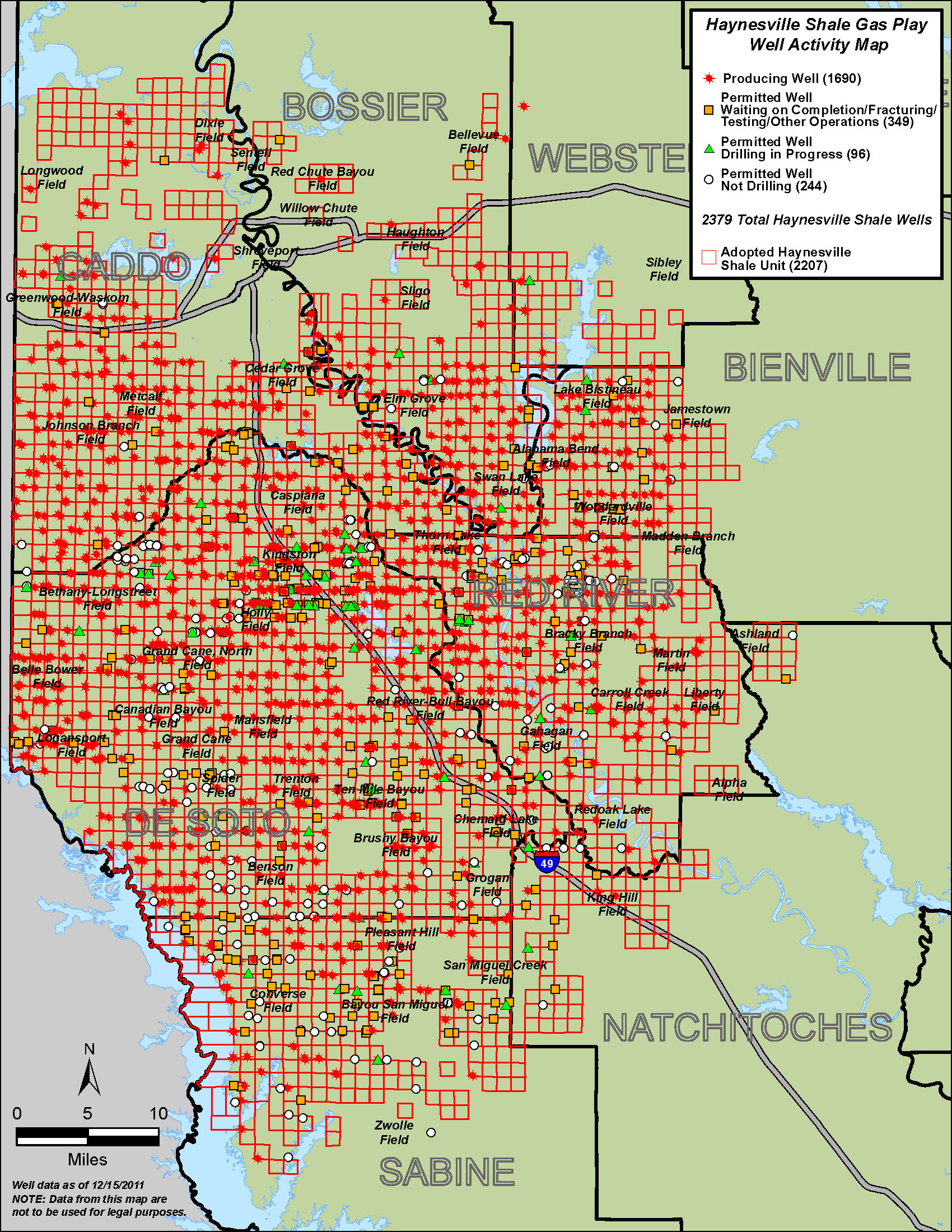
Within the state Department of Energy and Natural Resources, the offices of Conservation and Mineral Resources have roles in the exploration and production activity occurring in the state. Notice as of 11/2013: There is a new map legend for the Haynesville Shale Map. *Pre-production wells are those that are permitted, drilling, completing or shut-in. The Office of Conservation’s duties lie in the declaration of properties as units for the purpose of oil and gas drilling and production sites, permitting of wells, inspection of wells and audits of well production. The map on this site depicts some of that activity. The Office of Conservation has no jurisdictional authority over leases or leasing, or mineral royalty payments. No state government agency has a specified role in such agreements between private interests. Questions over terms of existing or proposed lease agreements between private individuals or groups might best be addressed by private legal counsel. The Office of Mineral Resources’ and Mineral Board’s duties lie in negotiating and approving mineral leases on state-owned lands and water bottoms, and mineral leases on local government-owned land when requested by the local government. The Mineral Board also has approval authority on all government mineral lease agreements, even if local government does its own negotiating. The Office of Mineral Resources only has authority in the leasing of government-owned property. No state government agency has a specified role in such agreements between private interests. Questions over terms of existing or proposed lease agreements between private land owners or groups might best be addressed by private legal counsel. |
| Clerk of Court Offices |
|
Caddo Parish Clerk of Court DeSoto Parish Clerk of Court Bossier Parish Clerk of Court Natchitoches Parish Clerk of Court Red River Parish Clerk of Court Webster Parish Clerk of Court Bienville Parish Clerk of Court |
| Other Websites and News Links |
| Websites |
| News |
|
| Reports |
|
| Presentations |
|
Jim Welsh, Louisiana Commissioner of Conservation |
|
| Professor Gary Hanson, Director Red River Watershed, LSU Shreveport |
|
| Mike Mathis, Chesapeake Energy's Regulatory Affairs |
|
| American Petroleum Institute (API) & Louisiana Oil & Gas Association (LOGA) |
|
*Any use of these slides without approval of the presenter is prohibited. |
| DENR News Releases, Memorandum, & Orders |
|
| Frequently Asked Questions |
|
What might happen if an exploration company is interested in leasing the mineral rights on my property ? Typically, a landman offers a per-acre amount to lease the mineral rights and a percentage of royalties from any production that is realized. What are surface rights? The term "surface rights" refers to the rights of use and enjoyment of property above ground, such as residential, agricultural, or commercial purposes. What are mineral rights? The term "mineral rights" generally refers to the right to explore and develop property for the production of oil, gas, and other minerals occurring naturally in liquid or gaseous form and to reduce them to possession and ownership. Ownership of land does not include ownership of such minerals, but the landowner or owner of a mineral servitude has the exclusive right to explore and develop the property for the production of minerals." How do I know if I own the mineral rights on my property? Owning land does not automatically mean you own the mineral rights to property. A search of your deed or property title at your parish clerk of court's office can tell you whether you own your mineral rights. If your current deed does not specifically discuss minerals, you may need to contact a professional in title research. In Louisiana, mineral rights can only be reserved (held by the seller of surface property) for ten years, either from the date of sale or from the date of the last exploration activity or production of minerals from the land. If there is no mineral development on the property in that time period, the mineral rights then automatically transfer to the buyer. What is unitization of wells? Unitization of oil and gas reservoirs in the state is a critical activity achieved by industry and state government working together. It is important to mineral rights owners because of the economic gain once a well is produced. At the request of an applicant or operator, an oil or gas unit is established for a sand, a zone, or a shale or formation. Unitization allows maximal recovery of the resource, prevents drilling unnecessary wells, and protects the rights of the mineral owners. Learn more here. What is forced pooling? The size of development well units is 640 acres or about one square mile. All mineral ownership within the 640-acres unit is initially shared in the production of a single well located within that unit on a surface-acre basis. This means that your square is ‘pooled' with others in the unit. Where do I go to find information about my property and my land rights? The Clerk of Court in your parish is the office to go to find legally recorded documents such as mineral leases, contracts, deeds and mortgages. Landowners with questions may also want to consult with an attorney for help with ownership issues. Do state government regulations help protect property and protect the environment as they relate to drilling operations in the state? Yes, Louisiana laws have both property and environmental protections under rules within the Office of Conservation. The Louisiana Administrative Code, Title 43 and the Office of Conservations' Statewide Order 29-B explain the regulations governing the state's natural resources. Learn more here. If my property is located above the Haynesville Shale formation, is there retrievable gas below my property? Not always. Exploration companies have expressed confidence that some areas of the shale formation have abundant natural gas that can be tapped using newer drilling methods, but that does not mean all parts of the formation will produce. |